Germany · Japanese Ink
Munich Map Poster · Japanese Ink
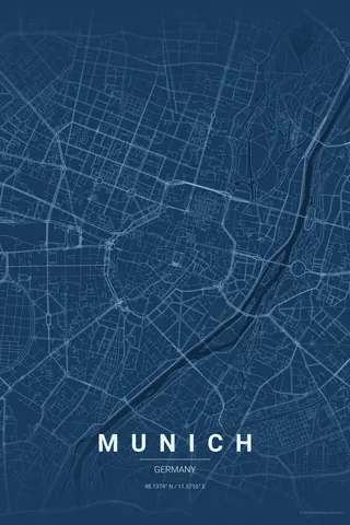
Every street, park and waterway of Munich, drawn from real map data in the Japanese Ink palette. Buy the files and print anywhere, or let us print it for you.
- Digital: 4 portrait JPGs (2:3, 3:4, 4:5, ISO) at 300 DPI
- Fits 12×18 in, 30×40 cm, 16×20 in, A4/A3/A2 and more
- Extras ZIP with the 11×14 in version and all ratios in landscape
- Printed sizes A4 to 60×90 cm, €29.90–€65, shipping included
- Map data © OpenStreetMap contributors
About the Munich map
the Altstadt ring, the Isar and the English Garden
Munich's map is built around a perfect little oval — the Altstadt ring that traces the old city walls around Marienplatz — with the Isar river running diagonally past it and the English Garden pouring green down from the north like a river of its own.
The contrast is what makes the poster: tight medieval core, generous Maxvorstadt grid, and one of the world's largest urban parks cutting the whole right side of the frame. Order and nature in one print.
Centre on Marienplatz with a 5 km radius: the Altstadt oval sits dead centre with the English Garden and the Isar framing it to the north-east. Munich rewards symmetry — keep the centre exact.
Read the full Munich guideWant it your way?
Change the distance, the colours, the label or the size in the editor and get a custom render of Munich.
Customize this design